What are the causes of urban floods in (Hyderabad) India and how have humans contributed to it?
The actions of humans are responsible for many of the problems that the world is currently facing. However, there is one problem that humans have caused which they are suffering from, and that is the occurrence of man-made floods in urban areas.
Recently, Hyderabad has been experiencing man-made urban floods. This is not just a problem limited to Hyderabad, but rather a widespread issue affecting all significant cities in the country that have undergone urbanization.
Sri Kavitha garu, journalist has shared a video on her Twitter account that depicts the impact of a flood. This is the situation at Padma Colony.#HyderabadRains pic.twitter.com/HmkbI6J3nj
— Nellutla Kavitha (@iamKavithaRao) April 29, 2023
To understand why flood occurs and to address the challenge of floods we need to understand some basic concepts of hydrology,
i) The first is the Catchment

A catchment area is a geographical region where surface water runoff flows into a particular water body.
When it rains, surface water runoff doesn't immediately occur from the catchment area. At first, the water seeps into the soil, saturating it until it reaches its maximum capacity. After the soil is saturated, it can't hold any more water, and the excess water starts flowing over the surface toward the nearest streams. These streams may combine to form larger ones that ultimately empty into a tank or river. If the rainfall is intense, it can cause floods.
To understand in simple terms, Think of a dry sponge that can absorb water. When water is added slowly, the sponge can absorb it all until it becomes saturated. Once it is saturated, any additional water added to the sponge will just flow out without being absorbed. Similarly, when it rains, the soil and vegetation act like a sponge to absorb water. However, if it rains heavily or for a long time, the soil and vegetation can become saturated and unable to absorb any more water. This excess water then flows over the surface, potentially causing a flood.
Imagine there is a concrete block instead of a sponge, very little water is absorbed, and the excess water immediately flows off the surface, The construction of buildings, pavements, and roads in the catchment area has a similar effect to the concrete block analogy. The impermeable surfaces created by these structures prevent water from infiltrating the soil, and instead, the excess water flows off the surface and accumulates in nearby streams or water bodies. This results in a higher volume of water entering the streams and water bodies than they are designed to handle, causing flooding.
The solution to all the problems will be discussed below but first, let us understand the causes of the flooding problem.
ii) The second is the Stream

A stream is a small to medium-sized natural waterway that typically has a current of moving water. Streams are a natural means by which water from the catchment area is transported to a larger water body, such as a river or a tank. The streams provide a pathway for the surface water runoff to flow downhill and merge with other streams, forming larger channels that eventually discharge into the water body. Streams form feeder channels to the Tanks. This process is part of the natural water cycle and plays a crucial role in maintaining the health of aquatic ecosystems and providing water resources for human use.
The Streams have a fixed cross-sectional area, which means that they have a limited capacity to carry water. If the amount of water flowing into a stream exceeds its capacity, the stream will overflow and cause flooding in adjacent areas.
As urbanization has progressed, there has been a rise in runoff caused by the factors mentioned earlier under the section of the catchment area. This should have resulted in an increase in the cross-sectional area of streams to enhance their capacity to handle floods. However, the opposite has happened. The streams have been encroached upon, leading to a reduction in their cross-sectional area, and a subsequent decrease in their flood-carrying capacity. This has resulted in flooding in nearby regions, similar to what is depicted in the video above of Padma Nagar in Hyderabad.
iii) The third is the Tank
A tank refers to an artificial reservoir or a man-made pond that is used for storing water. They can be used for a variety of purposes, such as irrigation, drinking water supply, and industrial use. In some cases, tanks may also be used for recreational activities such as fishing or boating. Tanks are often built by constructing a dam or embankment across a natural watercourse, thus creating a barrier that can hold water.

Tanks act as a form of flood control by providing a buffer that can hold excess water during heavy rainfall events. When the catchment area receives heavy rain, the water flows into the tank, which can temporarily hold the water until it can be safely released downstream. This can help prevent flooding in downstream areas and protect homes, businesses, and other infrastructure.
Suppose there are two tanks with different surface areas and depths of storage. Tank A has a surface area of 10 square meters and a depth of storage of 1 meter, giving it a total capacity of 10 cubic meters of water. Tank B has a surface area of 5 square meters, allowing it to hold 5 cubic meters of water.
In the event of rainfall with a volume of 15 cubic meters, Tank A would fill up to its maximum capacity of 10 cubic meters and release the excess 5 cubic meters of water. On the other hand, Tank B would only be able to hold 5 cubic meters of water, so it would fill up to its full capacity and release the remaining 10 cubic meters of water.
If heavy rainfall occurs and the tank can hold all the excess water, it can prevent flooding downstream. However, if the rainfall is too heavy and the tank reaches its storage capacity, the excess water must be safely released through the sluice or weir to prevent flooding.
Unfortunately due to Urbanization, the surface area of tanks is reduced by constructing houses and encroachments. This is reducing the buffering capacity of tanks.
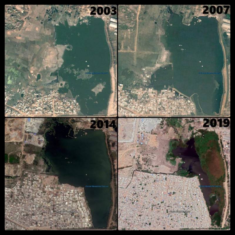
But why are the encroachments of tanks occurring?
The reason for these encroachments can be traced back to the rule of Nizam, where all the land belonged to the king and farmers had to pay taxes to cultivate their fields. Arable land, known as patta land, was owned by the king, while farmers were the enjoyers of the land. To maximize tax collection, during the summer when the water in the tank was less, the revealed surface was also cultivated, and such lands were treated as "Ek Phasli Lands." When the state of Hyderabad was merged with India through military action, the enjoyers of land became the pattadars, replacing the Nizam with the act.
However, governments forgot to isolate the tank lands, which needed to be protected and also gave pattas to these lands. Farmers then cultivated these lands. During the flooding season, the floodwaters inundated the crops for a few days, and there was no problem with the flood buffering capacity. However, with urbanization and an increasing population, the demand for land increased, leading to the raising of land and the construction of buildings and infrastructure around the tank area. This reduced the surface area and buffering capacity of tanks, resulting in flooding during heavy rains. Moreover, the catchment area of the tank is not protected, leading to soil erosion and sedimentation in the tank, which affects the water quality and storage capacity of tanks.
G.O. No. 111 emphasizes the protection of the catchment areas of Himayathsagar and Osman Sagar Lakes. However, the Government of Telangana has recently scrapped the G.O., which could lead to further urbanization and exacerbate the problems in the city of Hyderabad. The government needs to reconsider its actions and prioritize the protection of catchment areas and tanks to prevent flooding and maintain water quality.
Exploring Potential Solutions to Address Urban Flooding Issues
Urbanization has caused an increase in the runoff from the catchment area, and the decreased stream capacity combined with heavy rains is causing floods and damage to infrastructure the obvious solution is reducing the runoff without affecting urbanization which involves
for Catchment area:

a) Implementing the green roof: The grass grown on the roof of buildings with 3-4 inches of soil on the roof can act like a sponge. This addresses the problems of capturing atmospheric carbon dioxide, insects in the grass provide food for birds, which maintains ecological balance and it also helps in reducing runoff without soil eroding. This also helps in keeping the roof cool and decreases the cooling costs in summer saving energy, which is in line with the "Cool Roof Policy" of Telangana. Click here to know how to grow grass on your roof.
b) Connecting the green roof to the bore well: To further reduce runoff from green roofs, the water collected from the green roof can be filtered and connected to the borewell of the house. This allows the water to infiltrate deeper into the soil layers without causing surface runoff and can be utilized for later use, such as for irrigation or household needs. watch the video below to get a clear idea about it.
Implementing this system, not only reduces surface runoff but also recharges precious groundwater solving the problem of urban water scarcity.
c) Implementing permeable pavements: Permeable pavements are pavements that are designed to allow water to penetrate through them and infiltrate into the ground below. They can be used for sidewalks, parking lots, and even streets, and can help reduce the amount of runoff from paved surfaces.
By Implementing the above measures for Catchment areas the runoff is significantly reduced reducing the risk of Urban flooding.
For streams:
Streams carry flood water from the catchment area to the tanks, any reduction in their carrying capacity can cause flooding and hence the following measures may be implemented
a) Desiliting: To maintain the carrying capacity of streams and prevent flooding, regular desilting should be implemented to remove silt buildup. Additionally, the streams should be cleared of any vegetation, such as jungle and weeds, that may block the flow of water.
b) Removing encroachments: Strict action should be taken to deal with encroachments on streams. Illegal occupations must be removed immediately, while compensation can be paid for encroachments on land owned by individuals. Regardless of the nature of encroachments, they must be removed.
For Tanks:
Tank capacity plays an important role in flood mitigation, the more the tank capacity more the flood controlling capacity, hence the solution involves increasing the capacity in the long term and short term.
a) Short-term solution: involves deepening the existing surface area of tanks, thereby increasing the capacity of the tank.
b) Long-term solution: involves a comprehensive plan for calculating catchment areas and estimating flood volumes. This plan will determine the necessary surface area needed for each tank and mark it as a special zone. Satellite images as above can also help in marking the special zone.
The existing house owners in the special zone have already invested a significant amount in their properties, so immediate evacuation would cause undue hardship. Therefore, compensation will be paid to all land and building owners in the special zone at the present date, enabling them to plan for alternate housing arrangements.
New construction should not be allowed in this special zone, and buying and selling of properties will be prohibited. All existing owners must vacate the land by a specified cutoff date, which could be as long as 15 years from now. After the cutoff date, all structures will be removed, and the tank area will be reclaimed. This long-term solution will encounter minimal resistance and achieve the objective of tank reclamation.
To implement this plan effectively, all tanks in the state must be identified, and a special zone must be marked for each tank. This approach will ensure the sustainable management of tanks, preserving their capacity to provide vital water resources for the region.
In conclusion, man-made floods are a significant problem that urban areas are facing due to human intervention in natural water systems. The construction of buildings, pavements, and roads has led to impermeable surfaces, reducing the absorption of water by the soil and vegetation. Encroachment on streams has further reduced their capacity to carry water, while the reduction in the surface area of tanks due to urbanization has diminished their buffering capacity. As a result, heavy rainfall events are causing devastating floods in urban areas.
To address this challenge, a comprehensive approach that includes sustainable urban planning, proper land use management, and the restoration of natural water systems is necessary. It is essential to prioritize the implementation of the above-mentioned solutions to prevent further man-made floods and ensure the safety and well-being of urban residents.
Jai Hind.


Thank you for taking the time to read my message, and I would greatly appreciate any feedback or thoughts you may have. Your input is highly valued and appreciated.
ReplyDeleteSuperb abhiram
DeleteThank you Ratnakar.
Delete